Guide to Conguillío National Park, Chile

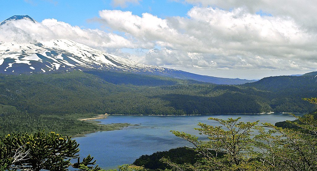
Conguillío National Park in the fall. Photo: Florencia Gehrung, CC BY-SA 4.0, via Wikimedia Commons
In the foothills of the Andes mountains, in the Araucanía Region, Conguillío National Park is one of Chile’s most breathtaking places. With its vast forests, stunning waterfalls, shimmering lakes, snow-capped volcanos, and amazing hikes, this is definitely one of my favorite spots in the country!
The park is located at the heart of the Mapuche’s ancestral lands and is where most descendants of these native peoples currently live. So, aside from its scenic attractions, this is a great place to learn about this indigenous culture and its traditions.
The park also protects one of the last large patches of monkey-puzzle trees, which are called araucarias in Spanish, and pehuén in Mapudungun, the local tongue.
With a great diversity of landscapes, there is an extremely broad array of activities to choose from when visiting the park, such as trekking, rafting, and skiing, among others. And if you just want to relax, the park will provide the necessary solitude for you to peacefully admire the wonders of nature here in the northern section of Chile’s famous Lake District.
Adventure, history, nature, and leisure all in one place! That’s Conguillío National Park.
Table of Contents
Plan your itinerary with local help

If you could use some help coming up with a great plan for your trip, schedule a Chile travel consultation with Carola, our Patagonia-based Local Expert!
These are one-hour Zoom calls where you’ll get to chat with Carola about the trip you’re planning and she’ll share her tips and advice, answer your travel questions, and help you perfect your itinerary.
Why visit
Aside from being one of Chile’s most beautiful national parks, Conguillío is part of the Araucarias Biosphere Reserve and the Kütralkura Global Geopark, two designations that highlight its international importance.
The iconic species of this park is definitely the araucaria or pehuén (monkey-puzzle tree), an ancient and endemic conifer exclusive to this part of the world and declared a natural monument in Chile. This is one of the last places in the country where you can see araucaria forests on their own or mixed with other trees, including several varieties of oaks and beeches.
Listen carefully as you walk among these forests, because you might hear or run into a famous cartoon character: did you guess who? It’s the woodpecker! Within the park, there’s even a special trail dedicated to this bird, which in general is really hard to find in Chile.
In addition to woodpeckers, the whole park is a sort of birdwatching paradise: 0ver 60 bird species have been identified here, and two spots in particular - Laguna Captrén and Laguna Arcoíris -, which I’ll describe in greater detail later in the article, are renowned for the excellent birdwatching opportunities they provide.
Aside from its lush forests and pristine lakes, the park’s lands are dominated and shaped by the imposing Llaima Volcano (10,630 feet tall), one of the most active in South America. In fact, the beautiful Laguna Arcoíris was formed by the damming of the waters of an estuary as a result of lava flows from the Llaima volcano, that flooded part of a beech forest, which you can still see sticking out through the crystalline waters of the lake. Definitely an eerily beautiful scene!
So, what else can I tell you to convince you to visit? Well, this is also a year-round destination. During the summer and warmer parts of the spring and fall, you can enjoy hiking and trekking, cycling, wildlife observation (if you’re lucky, you may even see a puma!), sport fishing, kayaking, rafting, and mountaineering, while in the winter you can practice skiing and snowboarding. There’s something for you here at any time of year.
Where is Conguillío & how to get here
Conguillío National Park is located in the Araucanía Region, approximately 435 mile south of Santiago, 92 miles northeast of Temuco, which is the region’s capital and the closest large city, and only 66 miles from the Pino Hachado International crossing to Argentina.
Nearby, Temuco is a prominent city with approximately 308,000 people, and it’s known as the gateway to the Mapuche heartland and to Conguillío National Park. From Santiago (as well as some other destinations in Chile), you can reach Temuco by plane, car, or bus.
Arriving by plane
All three domestic airlines (LATAM, Sky Airlines, and Jet Smart) have regular daily flights from Santiago to Temuco.
If you fly to Temuco, once you get to the airport, you will have three options to reach Conguillío National Park: hire a private transfer, drive a rental car, or take a public bus from the city’s downtown. Whatever you choose, it shouldn’t take you more than roughly 1.5 hours to get to the park, depending on which entrance you go to, since there are three access options - north, south, and west -.
Taking a bus from Santiago
Several bus companies offer long-distance trips between Santiago and Temuco, with the ride lasting about 10 hours. You’ll typically have a few departures each day.
Driving to the park
Alternatively, you can rent a car in Santiago and drive down the Pan-American Highway, also known as Route 5, which connects all of Chile. This option might be quicker than a bus, due to the speed-limit of 75 miles/hr, and it would allow you to visit other wonderful places (there are many!) along the route.
When to visit

Laguna Verde in early fall. Photo: Florencia Gehrung, CC BY-SA 4.0, via Wikimedia Commons
Although this is a destination that can be visited all year-round, in my opinion, the best seasons to visit Conguillío National Park are the summer (December to March) or the winter (June to September).
Which one is right for you will depend on what activities you’re looking to do while in the park.
Summer (December to March)
This is the high season in Chile, and the preferred one for locals to visit Conguillío National Park. This is the time of year with the lowest rainfall (although you might still get some downpours) and the highest temperatures, which range daily between 47° F and 75° F.
You’ve got the best chance of sunny days during the summer and longer daylight hours, which is what makes this the perfect time to come if you want to enjoy water sports, hiking, or mountain climbing. Even so, make sure to always carry a light rain jacket with you, as sudden showers and steep temperature drops are common.
During the summer, local tour operators offer lots of excursions, such as sunrise kayaking and a host activities for families/children, who are on school break between January and February.
Autumn (March to June)
This is the favorite season of photographers and poets because the entire forest is dyed spectacular shades of red and orange (fall foliage), and the landscapes are extraordinary. The trails are still open and up on the summits, the snow contrasts beautifully with the red leaves of the lenga beech trees.
Autumn is considered a mid-season (media estación) in Chile, and people usually dress in layers because the weather can go be quite variable. You might have a sunny morning and then a raging thunderstorm in the afternoon, so it’s always wise to carry a rain jacket/poncho. Daily temperatures range between 41° F and 70° F.
Winter (June to September)
This is the coldest season and the one when most attractions, except for those related to skiing, are closed. The northern and western accesses to the park are also shut down during these months because they can become impassible. This is also the season with the shortest days, with the sun setting by approximately 6:30 p.m. Daily temperatures range between 38° F and 53° F.
So, while the weather isn’t ideal for most activities, if you’re interested in skiing and other winter pursuits, this is the time to come. On the western slopes of Llaima Volcano, Araucarias Ski Center (6,400 ft) has ten ski tracks with various levels of difficulty that you can enjoy.
And although you can’t do much trekking, this is becoming an increasingly popular destination for off-piste skiing through the araucaria forests. It’s a breathtaking experience!
If you’re here in June, don’t miss the winter solstice celebrations held by the Mapuche communities, in honor of this sacred period (for them). It’s also a public holiday in Chile, known as Indigenous Peoples Day, and although the exact day varies, it usually falls between June 20 and June 22.
Spring (September to December)
As spring sets in, the winter snow makes way for lots of greenery of new life. Daily temperatures start to pick up, ranging between 40° F and 66° F, the days begin to get longer, and the trails start opening up again and camping is authorized once more.
Access to the park is still limited to the southern entrance at Melipeuco until approximately November, although each year is different depending on the weather (the other entrances sometimes open up earlier or later).
Despite the improving weather, spring can also be a dangerous time because of the threat of avalanches and the possibility of falling through melting snow or ice. Make sure that routes are safe before setting out on them and always carry the essential safety gear, which includes an avalanche beacon, a probe, a shovel, and a whistle.


How long to spend
The ideal number of days to spend in Conguillío National Park will depend on what your objective for visiting is. If you’re short on time, you can always book a simple full-day tour with any local operator in Temuco or from any of the other surrounding towna (there are mainly Melipeuco, Curacautín, and Malalcahuello).
If you can spare more time, then you should consider at least 2 days/1 night to make the most of your stay. In that case, I would propose the following itinerary.
Day 1
After your arrival in Temuco, head straight to Conguillío National Park and explore some of the most significant sites and easiest trails, like Truful Truful, Laguna Verde, Laguna Arcoíris, and Lago Conguillío.
Many of the major sights in the park have corresponding hiking trails of the same name, which either lead to or around them, so the names in the list above are both major sights as well as trails. For a complete overview of all 12 trails in the park, check out this site: https://sendasconguillio.cl/parque-nacional-conguillio/atractivos/.
Spend the night at your accommodation, either in the park, where you’ll find camping sites and cabins, or in any of the nearby towns.
Day 2
Get an early start to undertake the 6-hour trek of the Sierra Nevada trail, which will take you through an amazing forest of monkey puzzle trees. Along the way, you will also see various stunning lakes and waterfalls.
After a hearty lunch, take one last look at the park and then continue your journey to Temuco, Santiago, or wherever your wandering soul takes you next!
Where to stay
Lake Conguillio, around which many campsites are located. Photo: LBM1948, CC BY-SA 4.0, via Wikimedia Commons
The park itself has a number of different options for accommodation, should you decide to stay overnight within its boundaries. Alternatively, there are three towns that sit just outside the entrances to the park, which also make excellent choices for an overnight stay, especially if you’re looking for somewhere a bit busier to spend the evenings (more on each town below).
The park is managed by CONAF (the National Forestry Corporation, a governmental agency) along with two private companies that run all lodging and food services within the protected area.
Sendas Conguillío, manages the area surrounding Lago Conguillío and some parts next to the Llaima Volcano, while La Baita Conguillío, is in charge of the options closer to Llaima Volcano as well as to the southern entrance to the park. Here is a bit more information on the various options:
Campsites in the park
Sendas Conguillío has camping sites in two areas, Playa Curacautín and La Caseta, with each reservable space having the capacity for 5 to 8 people and room for 2 tents, as well as parking for one car. Three of the camping sites (Ñirres, Carpinteros, and Estero) can accommodate up to 5 people per night, and you can reserve a spot in advance at many of them.
In the Playa Curacautín area, there are four zones with 80 camping sites in total:
Los Ñirres: 42 sites. It’s the section closest to the Lake Conguillio (approximately 985 ft away) and the one with the most camping spots, which are distributed among the ñirres forest, a beautiful scenery of ancient trees.
Los Carpinteros: 11 sites. Located in clearings surrounded by ñirres and araucarias forests, it is discreet and located approximately 1,640 ft from the lake.
El Estero: 16 sites that fill on a first-come, first-served basis; they cannot be booked in advance. These sites are for shared use and the price is per person. This area is on the side of the main road, among the ñirres forest, 2,300 ft away from Lago Conguillío.
Mochileros: 8 sites that fill on a first-come, first-served basis; they cannot be booked in advance. It’s located on the side of the main road, among the ñirres forests, 2,300 ft away from Lago Conguillío. There’s no car parking, so it’s available only for people arriving on foot.
In the La Caseta area, there are two zones with 20 camping sites in total. Here, you can also book the site beforehand, and costs are per night for groups up to 5 people per site.
La Caseta: 10 sites. These are discreet places away from any crowd among the ñirres forest and on the shores of Lago Conguillío.
El Hoyón: 10 sites. These are discreet sites access to the best beach in Conguillío National Park.
If you can’t bring your own gear, a local tour operator (Turismo Pewen Mapu) based in Melipeuco rents all kinds of hiking, sports, and camping equipment.
The camping sites do not have electricity and the company has rules in place aimed at respecting coexistence with others and the environment, which is why quiet hours are from 11 p.m. until 8 a.m.
To keep the park well cared for, they ask that you please bring as little waste as possible and if you have a short stay (less than 3 nights), that you take all your waste out of the park yourself.
It is absolutely prohibited to make a fire with wood or charcoal, smoke any type of product, bring pets, damage flora and fauna, or feed wildlife.
All camping areas within the park are closed during the winter months (June to October) due to snow and low temperatures.
Cabins near Llaima Volcana
Sendas Conguillío also has 11 modern, warm, and well-equipped cabins at the foot of the Llaima Volcano, 6 of which have capacity for 2 people, and 5 which can accommodate up to 7 guests. They have fireplaces, hot water, and everything you may need (towels, kitchen utensils, and toiletries), as well as a private hot tub outside (available only from June to September).
To make sure you save your spot in any of the cabins or camping sites that allow it, book online on their dedicated website: https://reservas.sendasconguillio.cl/ or write to their email address: reservas@sendasconguillio.cl. [MS1] [Torres2]
La Baita cabins
La Baita has 3 modular rooms called cabins, 11 cabins called cabañas, and a lodge with a spa, also located at the foot of Llaima Volcano. The cabins consist of a bedroom and private bath but no kitchen area. However, they are close to the lodge and people staying in cabins can use the lodge facilities.
The cabañas are the traditional cabins we know and love, with several rooms. I highly recommend booking accommodations in advance through their official websites(https://labaitaconguillio.com/), since they tend to be in very high demand due to their excellent location.
Araucarias Ski Resort and Lodge
Araucarias Ski Resort (https://skiaraucarias.cl/alojamiento), on the slopes of Llaima Volcano, is another option within the park, especially if you come in the winter. It has two lodges, one of them with two large rooms with bunkbeds for 16 and 20 people, respectively, as well as an apartment building.
Towns and cities to stay outside the park
If you prefer to book accommodation outside the park, you’ll find plenty of options in the nearby towns of Melipeuco, Curacautín, and Malalcahuello. Each of these towns is close to one of the three entrances to Conguillío.
Melipeuco is a small town, with a population of approximately 7,000 people, located nearly 19 mi from the southern entrance to the park. This is where most local tour operators are based.
Curacautín is the largest urban area close to the park (24 mi away), with a population of roughly 19,000 people and an interesting legend of two star-crossed lovers.
Malalcahuello is a small settlement of barely 2,000 people located 33.5 mi from the park. It’s actually the gateway to another beautiful protected area, Malalcahuello National Reserve, and to some lovely hot springs.
Logistics of visiting
Opening hours
Conguillío National Park is open from Tuesday to Sunday from 8:30 a.m. to 6:00 p.m. (with entry not allowed after 2:00 PM).
The park is divided into three sectors, each of them with their own access point: Captrén on the north; Los Paraguas to the west; and Truful Truful to the south. This last one is the only entrance to the park that remains open during the winter.
Entrance tickets
Entrance tickets to the park cost approximately $15 USD and must be bought ahead of time and online through the dedicated website (click on ‘Idioma’ at the top to switch to English): https://shop.pasesparques.cl/evento/2560/parque-nacional-conguillio
To gain entrance to the park, you need to show the park ranger your printed pass or its image on your mobile device at the park entrance along with your identity card or passport. Purchase your pass in advance and avoid doing this at the park gates. If planning to use your phone to display the pass, remember that internet is not optimal in rural areas of Chile.
Getting to and around the park
There are no direct buses to the park, so if you want to travel here by bus, whether it’s from Santiago, Temuco, or the nearby towns, the closest you’ll get to the park is the town of Melipeuco. From there, you would have to hire a transfer to Conguillío.
Driving to/in the park
If you have a car, you can drive here and park within the park (there are designated parking aeas), but the drive here can be a bit tricky as not all roads are paved. In fact, some areas can only be accessed by a 4x4 vehicle, and it’s still risky even then.
The road in the park has some decent ascents, but they’re not especially steep. The bigger problem are the ruts that you’ll often find in the road, caused on wet days when passing trucks drive through and leave deep tire marks. These sometimes freeze over and then become completely rigid, and they make driving difficult and also pose a risk of scratching/damaging the underside of your car. So just be careful of this and drive cautiously.
If you decide to drive to the park, I would suggest leaving your car at the parking lot next to CONAF’s information booth by Lago Conguillío, or by the Los Ñirres and Los Carpinteros camping areas. This is also where most of the park’s trails begin, which are very well maintained, making traveling through the park on foot pleasant and easy.
Hiring a transfer or booking a tour
The other option is to hire a transfer or book a full-day tour with any of the local companies operating in Temuco or the nearby towns. I highly recommend touring with the local operators because they know the area incredibly well and can show you spectacular areas and provide so much background information that you would otherwise miss out on.
For instance, Mawun Tour offers private full-day guided excursions with pick-up and drop-off in Temuco. And Turismo Likankura offers regular daily guided tours departing from its offices in Melipeuco at 9:00 a.m.
The excursions last between five and six hours and take you to the most iconic sites in the park. They include transportation, your guide, and a snack platter to share while enjoying the breathtaking views, (you usually need to bring take your own lunch though).
Restaurants and facilities within the park
La Baita Lodge has a restaurant and a barbecue area, while Araucarias Ski Resort has a cafeteria in one of its lodges. Sendas Conguillío runs a restaurant, a small café, and a minimarket that are operational from December to March. They are located close to CONAF’s information booth by Lago Conguillío.
Their food variety is limited and more expensive than in the city, but they do have an assortment of sandwiches, snacks, and beverages. If you’re planning on camping or staying for more than one night in the park, I suggest stocking up in Melipeuco.
In this area you’ll also find a small restaurant run by a Mapuche entrepreneur, providing you with the unique opportunity to taste foods typical of these native peoples. You should absolutely make it a point to visit the restaurant.

Sectors of the park
The park is divided into three sectors, all of them focused on their own main attraction. As is the case with many places in Chile, the sectors, entrances, and trails tend to all share the name of the area or principal sight that they are closest to. Therefore, context is very important to understand if someone is talking about a trail, a sight, or something else!
The following are the sectors and entry points from north to south:
Captrén Sector/Access Point (north)
This covers mostly the area where Laguna Captrén and the Sierra Nevada hill are located, in the northwestern part of the park. It can be accessed through the Portería Laguna Captrén entrance, which is also known as the northern gate, and can be reached via the route R-925-S leading to the nearby town of Curacautín.
In order to reach that road, if you are traveling down Route 5 (the Pan-American Highway) from the north, you have to take the exit to the city of Victoria. If you are driving up from the south, take the exit to the city of Lautaro.
This entrance is closed during the winter.
Los Paraguas Sector/Access Point (west)
This sector encompasses the entire Llaima Volcano and adjacent lands extending towards the western entrance to the park, which is called Portería Los Paraguas. This is also the only way to get to Araucarias Ski Center, located on the western slopes of the volcano.
In order to access this sector and if traveling here along Route 5 (the Pan-American Highway), you should take the exits for the towns of Vilcún (if coming from the north) or Cherquenco (if coming from the south).
Truful Truful Sector/Access Point (south)
This is the southernmost sector in the park, covering landmarks such as Laguna Verde and Truful Truful waterfall. It’s also where the main entrance (Portería Truful Truful) is located and is the most popular and efficient way to get into to the park.
If coming here from Route 5 (the Pan-American Highway), take the exit for Cunco if coming from the north, and Melipeuco if coming form the south.
This is the only entrance that remains open all year long.
What to see & do
1. Do some birdwatching
Conguillío National Park is a great place for observing wildlife. With over bird 60 species recorded, it has been designated as an Important Bird Area (IBA) and has several spots where you can easily see other species.
The most famous one is Laguna Captrén, followed by Laguna Arcoíris, both of them close to CONAF’s information booth by Lago Conguillío and easy to reach through their corresponding enjoyable trails described below.
Some of the birds you may encounter that are only found in Chile include the Chilean mockingbird, the slender-billed parakeet, the Chilean tinamou, and don’t forget the woodpeckers. And if you’re lucky, you might even catch a puma or an endemic southern Darwin's frog!

A woodpecker typical to the park. Photo: Manuel Ramos Inostroza, CC BY-SA 4.0, via Wikimedia Commons
2. Go whitewater rafting
If you love rafting, then you won’t want to miss this adventure! Turismo Likankura, the local tour operator that created this excursion, offers half-day tours to go rafting down ten Class III rapids in the Truful Truful and Allipen rivers throughout the year.
This experience will take you through beautiful falls and forests. Departure times from its offices in Melipeuco - 8 mi from the main entrance of Conguillío National Park - are usually at 10:00 a.m. and 3:00 p.m.

A stretch of the Truful Truful river. Photo: Aeveraal, CC BY-SA 4.0, via Wikimedia Commons
3. Sign up for a race in Chile’s only Geopark!
Conguillío National Park is encompassed by the Kütralkura Global Geopark, a broad network of sites, including some in nearby towns, where conservation goes hand-in-hand with sustainable development. It roughly extends from Tolhuaca National Reserve in the north to Villarrica National Park in the south, and from approximately 9 mi away from Temuco on the west to the border with Argentina on the east.
Since 2022, each year in January and October, the Geopark holds the Kütralkura Trail Race for distances ranging from 2 to 42 km (approximately 1.2 to 26 mi). The circuit covers some private lands, as well as part of Los Paraguas Sector in the western part of Conguillío National Park.
UNESCO Global Geoparks are geographical areas where sites and landscapes of international geological significance are managed with the involvement of local communities. There are currently 213 UNESCO Global Geoparks in 48 countries, and this is the only one in Chile!
Some of the ‘geosites’ in Conguillío National Park that are also part of Kütralkura Global Geopark include Lago Conguillío, the Captrén-Pastos Blancos trails, and Laguna Arcoíris, to name a few, as well as several service and accommodation providers both within the park and in the surrounding towns of Melipeuco, Curacautín, and Malalcahuello.
You can check out the website and find out more about the Geopark, as well as its associated attractions and local tour operators.
4. Climb to the summit of Llaima Volcano
This is a dream come true for many mountain fans. If you’re up for it, you should definitely give it a try! Llaima Volcano is one of the main landmarks of the park, located towards the west.
Over the centuries, it has shaped Conguillío’s hills and lakes with its lava flows and it’s one of its most outstanding attractions. A local tour operator - Turismo Pewen Mapu - offers guided full-day excursions (from 4:00 a.m. to 8:00 p.m.) from their offices in Melipeuco to help you reach the top of this stunning mountain (10,630 ft), mostly between October and April.
From there, you’ll have a 360° view that will allow you to see more than 11 volcanoes, part of Argentina, and almost the entire Araucanía Region!
The tour includes transportation between the volcano and the town of Melipeuco, safety gear, and photographs. This is a tough climb, so you need to be at least 17 years old and in good physical condition to attempt it. You will also have to pay entrance to the park, take your own boxed lunch, and purchase medical insurance to cover any potential accidents. Remember you’ll be in the snow, so pack accordingly!

Photo: Mpazmarzolo, CC BY-SA 4.0, via Wikimedia Commons
5. Savor some typical Mapuche food
Mültrün, muday, piñónes, and merkén are some of the traditional Mapuche foods you’ll be able to try in Conguillío National Park and its surroundings. The catuto or mültrün (in Mapudungun language) is a pastry made with wheat and then boiled or fried and served with honey, while the muday is a wheat cider.
The piñones are the seeds of the monkey puzzle tree (also called araucaria in Spanish) and a significant component of the regular diet of these communities, since they grind them to make flour.
The merkén is a red chili powder, a classic ingredient in Mapuche foods. It’s made from smoked cacho de cabra (goat horn) chili, which is ground and combined with other spices, resulting in a condiment with an intense and spicy flavor.
Ruta al Conguillio restaurant, located next to CONAF’s information booth by Lago Conguillío, is a great place to taste these flavors. Another very good option is Folil Koyam, in the town of Melipeuco.
6. Stare in awe at the Truful Truful waterfall
This is one of the main landmarks and most beautiful places of the park, located very close to its main entrance on its southern border. It’s also a sacred site for the Mapuche people. With a 26-feet drop and beautiful turquoise water, this set of waterfalls is located in the upper area of the Truful-Truful River.
They are fed by snowmelt from the Llaima and Sierra Nevada volcanoes and inserted in a volcanic slag that - together with the basaltic and volcanic layers - has generated a plateau crossed by the river.
To reach the waterfall, you need to follow the trail of the same name, which will take you along the Truful Truful River canyon and allow you to appreciate a magnificent 246-feet wall that shows a layered record of the intense eruptive history of the Llaima volcano over the last 13,000 years.
Here, you can see the different types of eruptions that the volcano has had depending on the color and composition of the material. It’s really amazing!

Photo: LBM1948, CC BY-SA 4.0, via Wikimedia Commons. Cropped from original
7. Llaima Volcano
This is a very interesting structure, although most know it only as the Llaima Volcano, it’s actually a geological group of peaks and smaller cones that developed due to the violent eruptions it has had in the past, which have also shaped the surrounding landscape. Although its latest eruptions have been relatively calm, it is still considered one of the most active volcanos in the country and South America.
The volcano has two main peaks and roughly 40 smaller cones that are emission centers spread throughout its slopes and surrounding areas, all of them have the potential of erupting and releasing lava flows.
The northern and main summit has a relatively regular and symmetrical conical shape, standing at 10,480 ft, and holds its only crater, which is 1,148 ft in diameter and more than 984 ft deep, while in the southern summit – locally known as Pichillaima or “small Llaima” and with an altitude of 9,580 ft - you can see the remains of a small cinder cone nested in an obstructed crater that is approximately 656 ft deep.
The western, southwestern, and eastern slopes are covered by roughly 11 sq mi of glaciers. During the summer, you can ascend the volcano with one of the authorized local tour operators. The experience is breathtaking!
8. Laguna Arcoíris
This lovely small volcanic lake is among the easiest park landmarks to visit and an Instagram sensation! Its intense green, deep blue, and transparent waters cover a flooded forest dating back to 320 years according to radiocarbon studies carried out on charred wood from it. The lake was formed when a lava flow from the Llaima volcano caused the damming of an estuary.
Follow the trail - in between the main entrance on the park’s southern border and the administration - and take the time to sit down and relax. This is a great place to practice some mindfulness!

Photo: Wpriscy, CC BY-SA 4.0, via Wikimedia Commons
9. Lago Conguillío
Covering nearly 3 sq mi, this is the largest lake in the park and like all other water bodies here, it was created as a result of being dammed by lava emanating from cones surrounding the Llaima volcano. It’s continuously recharged by waters that come from the melting of the glacier of the Sierra Nevada volcano.
Because it does not have torrential rivers as tributaries, the lake remains calm and with crystal clear waters that allow you to see the bottom and the trunks of the ancient trees that were flooded under the water when the lake was formed.
The drainage is produced underground, purifying the waters and leaving large beaches suitable for bathing in the summer period. One of the most beautiful is Playa Linda, where you can practice sailing, fishing, and photography.
10. Laguna Captrén
This volcanic lake – also featuring submerged forests – is a preferred bird watching site because of the great variety of species you can find here and on the trail that leads to it. It was created by the melting of the Sierra Nevada glacier and it’s surrounded by ancient forests.
You can see the lake completely frozen during winter and until the beginning of spring, transforming into a snow-covered fairytale setting.

Photo: Mariomxel, CC BY-SA 4.0, via Wikimedia Commons
11. Sierra Nevada Volcano
Located on the eastern shore of Lago Conguillío, the inactive Sierra Nevada volcano (8,379 ft) is another one of the park’s main attractions. You can explore part of it through a trail with three lookouts that I describe in greater detail below or by attempting to climb it.
This is no easy feat, though, so make sure you have the necessary equipment and technical knowledge in mountaineering or skiing beforehand. You will only be allowed to ascend with an authorized tour operator, such as Vida Nativo or Rutas Australes.
When you reach the top, you’ll be rewarded with an awe-inspiring 360° view of the park, including Lago Conguillio and Llaima Volcano, as well as other volcanos farther away, like the Lonquimay, Tolhuaca, and Callaqui volcanoes towards the north.


Best trails and hikes
With 12 trails of different difficulty levels that are accessible almost all year-round, Conguillío is famous for its hiking opportunities. However, the crown jewel, so to speak, is the Sierra Nevada trail, which passes through monkey puzzle trees, lakes, and waterfalls.
Other popular trails include the Laguna Captrén, Los Carpinteros, Laguna Arcoíris, and Truful Truful trails, each of which I’ve described below.
For maps and further information about the park’s trails (provided by other travelers), you can check out the information on this trekking site.
1) Sierra Nevada Trail (Captrén Sector - North Access Point)
This 7-mile loop trek has an elevation gain of 1,975 ft and takes between five and six hours to complete, so you must remember to bring water, snacks, and sunscreen with you. You’ll ascend up a moderate slope that borders Lago Conguillío, heading from south to north along the hill of the extinct Sierra Nevada volcano.
On the way to the spectacular Sierra Nevada lookout (perhaps the highlight of the trek), you will run into the Conguillío and Los Cóndores lookouts, which also provide spectacular panoramic views of the park, the lake, and the nearby mountain ranges.
2) Los Carpinteros and Laguna Captrén Trails (Truful Truful Sector - South Access Point)
These two trails are usually done together, because the only way to reach the Laguna Captrén Trail is to first undertake the Los Carpinteros Trail. Starting at the parking lot next to CONAF’s information booth by Lago Conguillío, the 3.7-mile (one-way) Los Carpinteros Trail leads you through beautiful forests, with an elevation gain of 1,287 ft. It takes about 3 to 4 hours to complete round trip.
During the hike, you’ll get to see the Araucaria Madre (Mother Araucaria), a monkey-puzzle tree that is estimated to be 1,800 years old and which has a diameter of almost 120 inches!
At the end of Los Carpinteros Trail, you’ll encounter the Laguna Captrén Trail, which runs around the small lake Captrén, a site beloved by birdwatchers. The Laguna Captrén Trail is approximately 1.2 mi long and takes roughly one hour to complete.
So altogether, this hike will take you about 5 hours to complete, covering the total 4.9 mi of both trails.
3) Laguna Arcoíris Trail (Truful Truful Sector - South Access Point)
The Laguna Arcoíris trail will take you to a small lake of the same name, located quite close to the southern park entrance, Portería Truful Truful. Reached via an easy 45-minute trek, this beautiful lake, with its flooded forest protruding through its waters, is one of the traditional postcard images of the park.
4) Truful Truful Trail (Truful Truful Sector - South Access Point)
Located at the entrance from Melipeuco, Portería Truful Truful, this is one of the most easily accessible trails and it only takes approximately 30 minutes to complete the loop. It leads through the Truful Truful River canyon to a stunning waterfall, which is among the most beautiful in the area.


- Chat with a local expert
- 1 hour planning session
- Get pro tips & hidden gems
- Personalized to you


Carola Fresno
Chile Expert based in Patagonia
¡Hola y buenos días! 👋
I'm Carola, and I've been a tour guide & travel consultant here in Chile for the last 14 years. If you're looking for some local advice on your trip, I'd love to help!
Learn more Book a consultation


Chat with a Chile expert